Maps Page on
Country/Region
Outline
- Physical Environment
- First
map Physical map of Pakistan
(National capitals)
- Map of Pakistan’s
Administrative zones/Prefectures
- Elevation map of
Pakistan
- Weather & Climate
- Pakistan Earthquake
Zone Map
- Pakistan Climatic
Regions, Rainfall map
o Seismic map of Pakistan.
- Human Environment
o Population of Pakistan in term ethnicity
o Population density of Pakistan.
- Pakistan map of
housing type by population.
- Road maps
- Pakistan road map depicts the highways and major
roads of the Pakistan
o CPEC MAP
o National Highway map of Pakistan.
- City Maps
o City Map of Lahore with main roads
o Met blog Lahore
o METRO line map of Lahore.
- Urban Transportation Maps
o Motorway Plan map of Pakistan.
o Sammi Daewoo Express Sub-terminals
o Transport (bus, subway, airport) detailed map
- Tourist Maps
o Tourism map of Pakistan
o Touristic site of Pakistan with icon.
o Tourist map of Pakistan in terms of linguistic diversity and landscape as desert.
1 Physical
Environment
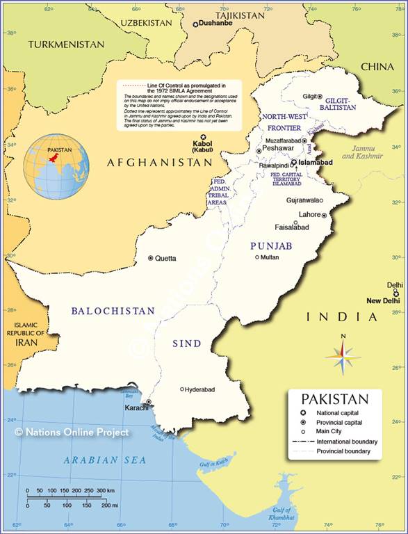
a) First map Physical map of Pakistan (National capitals)
This physical map of Pakistan is showing major
geographical features of the country such as elevations, mountain ranges,
deserts, seas, lakes, plateaus, peninsulas, rivers, plains, landforms and other
topographic features differentiated by colors or represented by lines on the
map. On the map we can see the bordering countries of Pakistan as being
Iran to the southwest, India to the east, China in the northeast and finally we
have Afghanistan which is in the west.
 https://www.ezilon.com/maps/images/asia/Pakistan-physical-map.gif
b)
Map of
Pakistan’s Administrative zones/Prefectures
This map is showing the surrounding countries around Pakistan
so as states borders, province borders, the national capital Islamabad, provincial
capitals, and largest cities as Lahore, Quetta, Karachi, Hyderabad, Peshawar,
Islamabad. The map also shows how Pakistan is a federation of four
provinces Baluchistan, Khyber Pakhtunkhwa, Punjab.
https://www.nationsonline.org/maps/pakistan-administrative-map.jpg
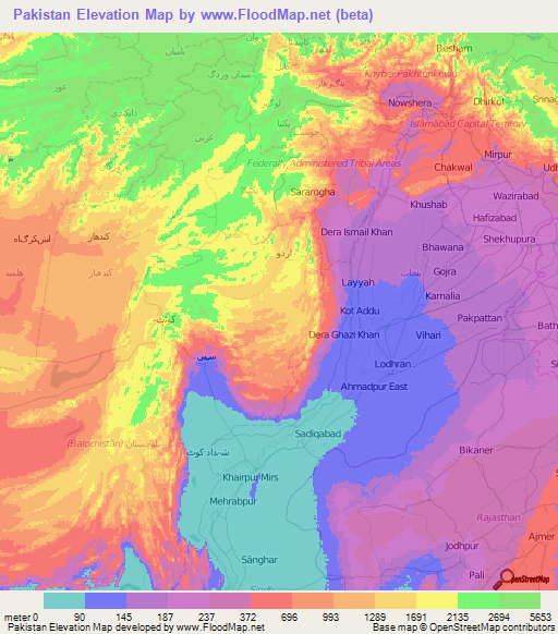
c)
Elevation map of
Pakistan
Below are the elevation maps of Pakistan for
different zones
This map shows the different zones and their
elevations. The gradient colors represent the degree to which each region of
Pakistan fits in terms of elevation. With the different colors we can see how
from one region to the other, the elevation is not the same.
 http://www.floodmap.net/Elevation/ElevationMap/CountryMaps/?cz=PK_2
2 Weather &
Climate
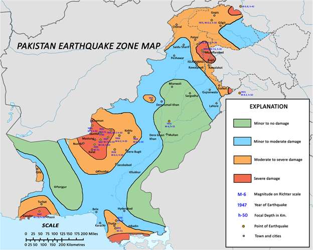
a)
Pakistan
Earthquake Zone Map
Known as one of the most seismically active countries in the world, Pakistan is being crossed by several major faults as well. As a result, earthquakes in Pakistan occur often and are known to be very destructive. This map displays areas where earthquakes occur and with which intensity. The colors allow to classify region where there are minor to no damage after an earthquake, those with moderate, severe damages and the magnitude of those Earthquakes by region of occurrence.
b)
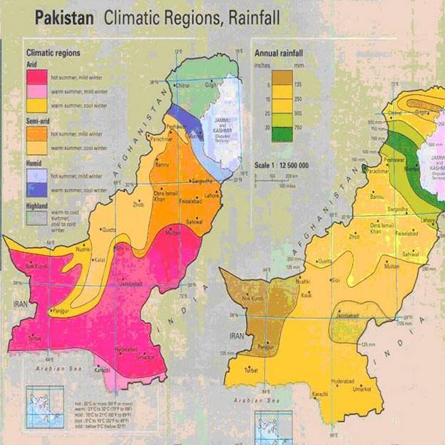
Pakistan
Climatic Regions, Rainfall map.
This map aims to show the different regions of Pakistan and their climatic condition and amount of rain that each place accounts for by year. We can differentiate on the map the different region by the color. While there are arid, semi-arid, humid regions so as highland. There are regions based on information from this map which have as much as 750 mm rainfall per year while the lowest could go as low as 125 mm.
https://maps-pakistan.com/img/1200/pakistan-climate-map.jpg
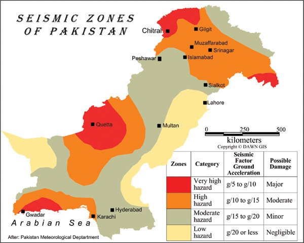
c)
Seismic
map of Pakistan.
This map does display the main regions where there are seismic movements in Pakistan. From one zone to another there seems to have different factors for explaining the reason why seism occur, with each zone represented by a color, a color which corresponds to degree of hazard and possible damage. Therefore, the major cities represented in this case are Chitral, Peshawar, Islamabad, Lahore, Muzaffarabad, Gilgit, Srinagar, Sialkot, Multan, Quetta, Gwadar, Hyderabad, Karachi.
 https://pbs.twimg.com/media/CSvfFFHXIAET0uG.jpg:large
3 Human Environment
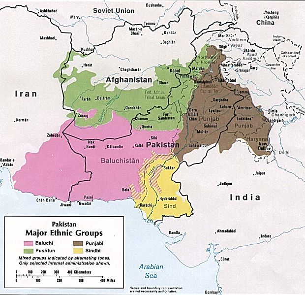
a)
Population
of Pakistan in term ethnicity
This map presents the different major ethnic groups in Pakistan by region around the year 1980 that was estimated to be around four major one, which are Baluchi, Pashtun, Punjabi and Sindhi. The more dominant ethnic group is displayed to be Baluchi represented by the pink color mostly present in the southwest side of the country close to the border of Iran; followed by Pashtun represented in green found primarily in the north side of the country. Sindhi and Punjabi are the minority.
 http://www.marysrosaries.com/collaboration/images/e/eb/Pakistan_ethnic_Group_Map_1980.jpg
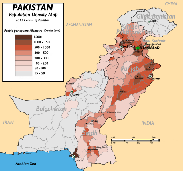
b)
Population
density of Pakistan.
This map shows the population density of the country of Pakistan with different colors representation in which the map shows the amount of people per square kilometer by district. Big cities such as Islamabad, Lahore, Peshawar, Karachi have the majority of people per square kilometer about 1500 people and more.
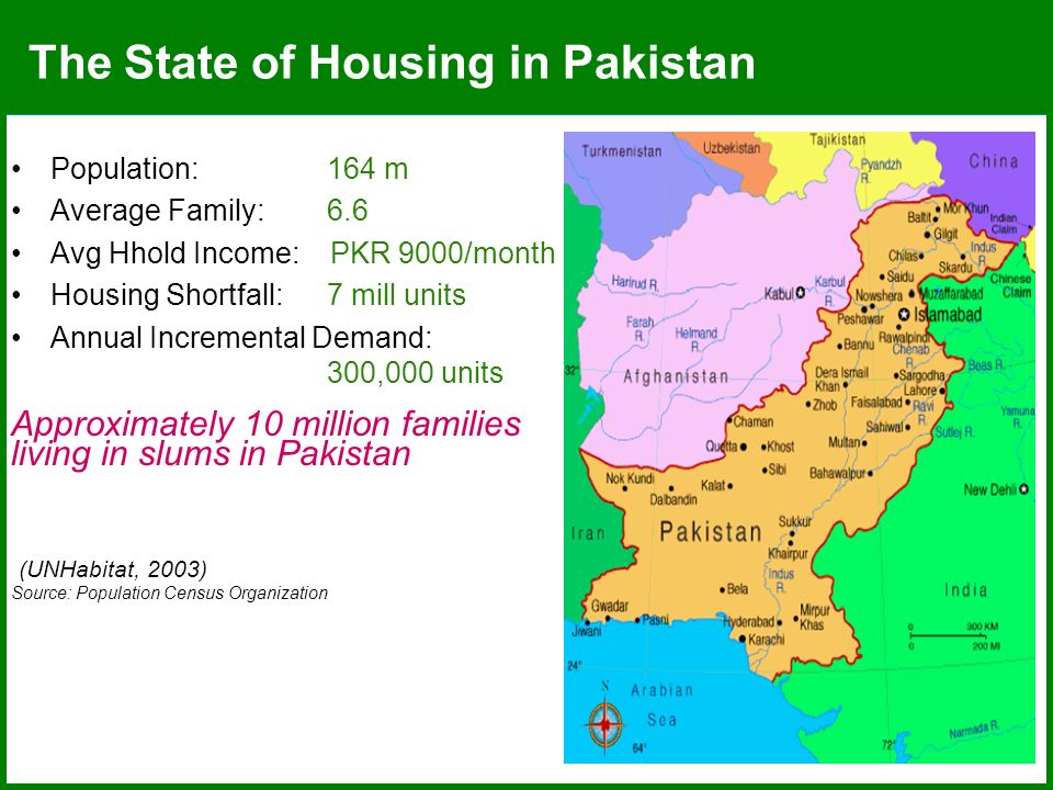
c)
Pakistan
map of housing type by population.
This map shows the different areas where people lives according to their income and their family size and which housing type are mostly in demand annually. The map is supposed to be a representation of the accessibility and affordability of various type of housing in Pakistan.
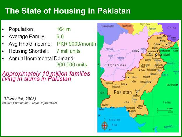
https://images.slideplayer.com/21/6321717/slides/slide_4.jpg
4 Road Maps
a) Pakistan road map depicts the highways and major roads of the Pakistan
This map shows the major roads and highway of
Pakistan highlighted in yellow and so as the international boundaries between
the country and surrounding countries like Afghanistan, China, Iran and India
which are represented by broken dark black lines. On this map we can see that
Islamabad is the capital with the symbol that’s on it. To differentiate
the big and other cities, we can see that there is a yellow dot on big ones and
white one on others. Also while main roads are traced by the yellow lines,
white lines do represent normal roads.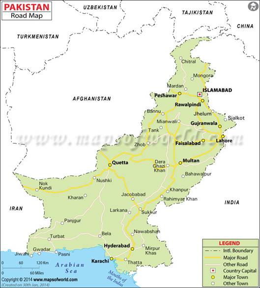 https://www.mapsofworld.com/pakistan/maps/pakistan-road-map.jpg
b) CPEC MAP
This map shows the western route of the China-Pakistan Economic Corridor commonly known as CPEC which connects the port city of Gwadar with Quetta via Khuzdar, with main highway lines. Each line on the map represent a specific route. While purple lines represent Long term CPEC alignment, green lines represent the routes of Peshawar Karachi Motorway.
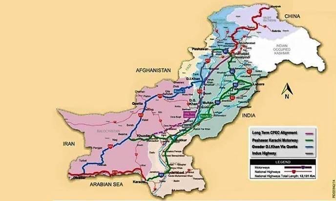
http://i.dawn.com/large/2016/01/568c654b3b214.jpg
c)
National
Highway map of Pakistan.
This map presents various different routes of the National
Highways Network Map of Pakistan from National Highways represented in blue,
Motorways represented in green and solid lines and also broken lines,
Expressways represented by the color purple and red representing Strategic
Roads. There is also an orange routes that represents major arterial
roads.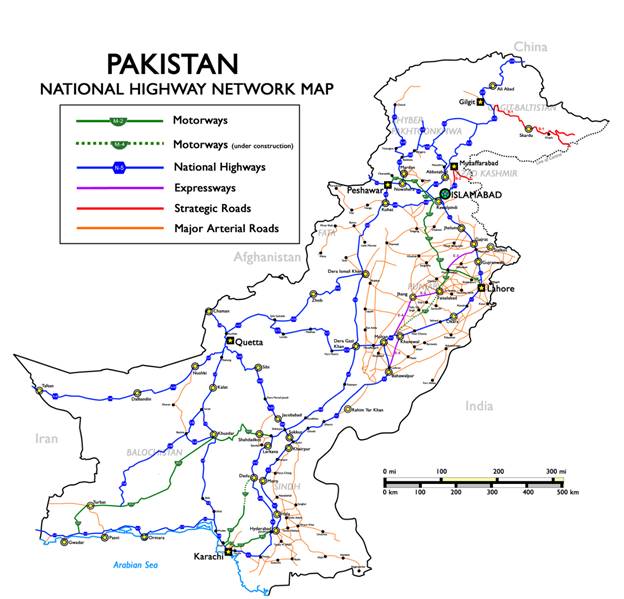 https://upload.wikimedia.org/wikipedia/commons/2/2a/Pakistan_Nationalhighways.PNG
5 City Maps
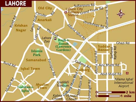
a)
City
Map of Lahore with main roads
This map shows the city of Lahore, Pakistan with the main road of the city. With amusement park written in green and zoo written in brown. This map also displays the Lahore City Railway station with the airport of the city. Basically, this map shows the main features of the city.
https://www.lonelyplanet.com/maps/asia/pakistan/lahore/map_of_lahore.jpg
b)
Met
blog map
Met blog Lahore lines with big and small roads. Each road represented by a number and the map featuring roads connections and streets and neighborhood cities of Pakistan around Lahore.
http://lahore.metblogs.com/files/2010/01/Google_maps_Lahore_before_n_after.png
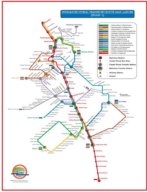
c)
METRO
line map of Lahore.
This map shows the trajectory line of the metro in Lahore and the main roads that are being taken. There is no display of the stop unfortunately, but each color represents a different metro line and wherever those lines meet will mean that there is a stop at that intersection connecting the two line of metro.
6 Urban
Transportation
a)
Motorway
Plan map of Pakistan.
We can see that this map displays the different metro lines that connects the different cities of Pakistan. The red line represents the motor way while the blue dot represents each stop which are basically representative of each cities of Pakistan.
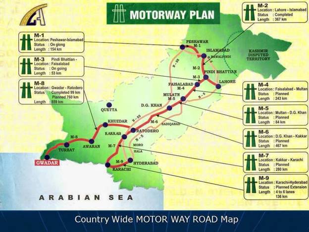 http://3.bp.blogspot.com/-IkFEaqeMcDs/U4AfDKdfGFI/AAAAAAAAHHk/Z2ckpBzQ9H0/s1600/Motorway+Plan.jpg
b)
Sammi
Daewoo Express Sub-terminals
This map is a simple
representation of what the subway in Pakistan looks like, showing the stops
(terminals) of each city so as the boundaries between provinces. The map shows
how there are different connection between the different cities.
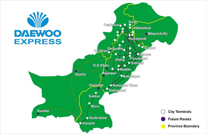
http://visitpak.com/wp-content/uploads/2013/03/daewoo-terminals-in-Pakistan-contacts.jpg
c)
Transport
(bus, subway, airport) detailed map
This map is a descriptive map of the subway and bus system of Pakistan. It shows how it works, what are the symbols for the stops of the bus, the subway and the airport. The map is enough detailed for us to see where there are each stops and the color that goes with each type of transportation. But also, the name of each stops or streets where there is a stop.
 https://www.morenews.pk/gadgetphoto/Metro%20Bus%20Feeder%20Routes.jpg
7 Tourist Sites
a)
Tourism
map of Pakistan
This map shows the roads to the different touristic sites of Pakistan with boundaries lines, rivers lines, countries capital, and many more which basically is representative of a roadmap of Pakistan with highlighted features representing focal points of the countries in terms of tourism. It Basically shows you how to manage to move around the country to visit some popular site through the motorway which is why there are couple motorways signs displayed on the map to show a stop.
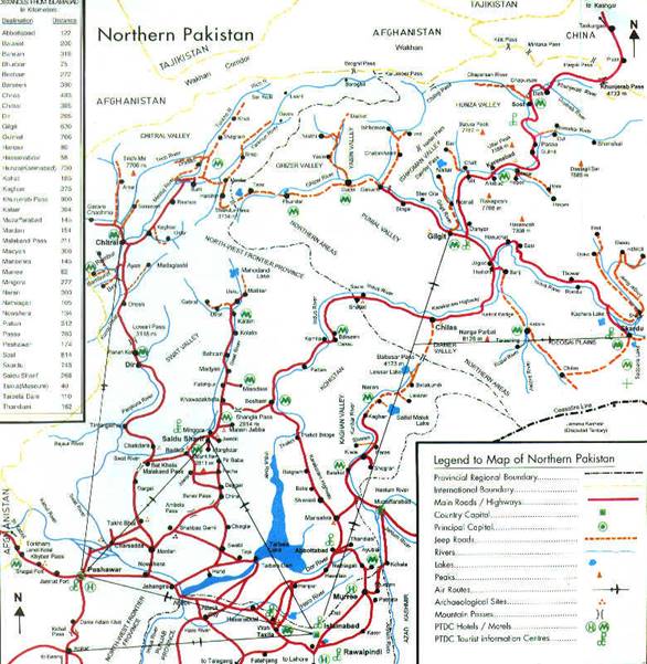
http://pakistanpaedia.com/provinces/na/map_northern-areas-Pakistan.jpg
b)
Touristic
site of Pakistan with icon.
This map shows the various sites that could be visited in Pakistan different from the previous map because, it highlighted each single site by putting a small image of what the site looks like at the location of the place. The map basically shows each city of Pakistan and what sites each one has to offer. Nevertheless, there is no big notation just draw lines representing connecting roads, rivers, main roads and motor way roads with each represented by a different color.
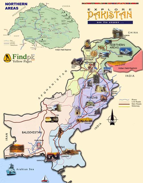
http://www.findpk.com/Pakistan/Explore_Pakistan/ExplorePakistan.gif
c)
Tourist
map of Pakistan in terms of linguistic diversity and landscape as desert.
This map shows the diverse languages that are spoken in the entire country and the different Landscape that could be visited desert wise, with the desert of TRAR. It also shows which products Pakistan has that contributes to their economy on top of tourism. We can list: Sugar, rice, wheat, cotton and where each one is found by region.

http://travelquaz.com/wp-content/uploads/2015/09/pakistan-maps-u2022-mappery1.jpg
Submitted
by [krystel Audrey Sophie Sidiki Bolanga] on [Friday March 1st,
2019].